0042. NZ Part 2. West Coast. 17th - 26th September 2023
 |
| Our home for 3 weeks |
Woke up on the morning of the 17th, still stiff, but ready for the next phase of our Adventure - Time to go and pick up our little rental Toyota Campervan. The head office for Freedom Campers is in Christchurch, but it was cheaper and easier for us to pay the excess and have the van delivered to us in Queenstown instead of flying to Christchurch. And it also suited our planned itinerary to see as much of the N Island as possible. So, leaving our bags at the great little Bella Vista motel, we walked in to town to catch the bus to the airport. Unfortunately buses in Queenstown not quite as punctual as those in The Netherlands - The bus was almost an hour late in arriving - Apparently one had broken down somewhere !! Anyway, eventually got to the airport and found our van and driver in the car park, where we had a brief hangover before he left us to it. The camper is an older unit (reflected in its low price) but very similar in many ways to our Troopy camper back home, so nothing too much to learn. So we headed back to the motel, picked up our bags from the motel, and set off down the road.
 |
| Lake Wakatipu |
For our first night on the road I had planned an easy drive to the very northern end of Lake Wakatipu - A place near Glenorchy, and I targeted a place called Kinloch, not knowing what to expect. The excellent weather was continuing, and we had a spectacular drive along the eastern shore of Lake Wakatipu, and we then stopped in Glenorchy at the delightful Mrs Woolly's General Store which had all sorts of foodstuffs as well as books, woollen goods, and everything in between. We had
 |
| Dart River Estuary at Kinloch |
already stopped at a supermarket and bought some food supplies, so we then headed on towards Kinloch. Unfortunately there was a dirt road, and initially it was quite rough with corrugations, and we very nearly turned back. Luckily we didn't and
 |
| Our first nights campsite |
about 10 kms further up the track we came out at a delightful spot on the banks of the Dart River, with a few others already camping there, plus a little lodge which had guests for the weekend and a full restaurant there ! We had experience sandflies on the Milford Track, but here they took on a whole new meaning and we were soon shut inside our van. The sandflies are ok if you are moving, but if you stop or sit down, they attack viciously !! But the van set up easily, and we were able to cook our supper inside, then made up the bed and turned in. All good.
 |
| Shotover Jetboats |
Next morning, avoiding sandflies as much as possible, we breakfasted then set off back down the dirt road. A coffee and bite to eat at Mrs Woolly's General Store, then we drove back down the side of Lake Wakatipu, through Queenstown, and out to the Shotover River and Canyon, where we watched the Jet Boats playing around before the disappeared up the canyon. Would be fun to do, but we had other things to do !! From there it was off up the very scenic Crown Range Road, at the Summit of the Pass we could look back down to Queenstown, even
 |
| Crown Range Road |
seeing the airport and a commercial jet flying in below us into Queenstown. Now we understood why it was such a fun approach when we arrived from Brisbane a week earlier ! Then it was Arrowtown, the historic Gold Mining town on the Arrow River, and after a quick visit it was on to Cardrona and the famous pub - Apparently one of the most
 |
| Cardrona Hotel |
photographed buildings in Australia. It is a beautiful building inside, so we stopped and had a quick beer before heading on towards Wanaka, where we went to the supermarket for supplies and then filled up with fuel and checked our fresh water tank was full, before heading on through the scenic Lindis Pass, shortly after which it was time to stop for the night. We found the Dunstan Downs Sheep Station that offered camping, which sounded fun, but turned out to be an expensive piece of grass on which to park, and with below average facilities. Hmmmm.
 |
| Terrible Dunstan Downs camp |
Next morning, after chatting to a German couple who were cycling the same road, we headed out towards Twizel, which doesn't have a lot to offer, but gave us a chance to top up with fuel and go to the bakery for a coffee and sticky bun. We also found a hardware story where we found some chemical to treat our Porta Potty so it didn't smell (very important !) and then a tiny bookstore where they had a copy of the NZ Lonely Planet book - to replace the one we had left on the plane !! It was then off towards Mt Cook, and we drove north up the western shore of Lake Pukaki, which with the clear blue skies above, was absolutely stunning. And then Mt Cook and its surrounding mountains came into view at the head of the lake, and we were absolutely gobsmacked - Truly stunning scenery and just perfect weather
 |
| Mt Cook over Lake Pukaki |
to show it off at its absolute best. At the head of the Lake, we drove alongside the Hooker River up to Mt Cook Village, where there is lots of accomodation, and also an Information Centre and the Sir Edmund Hilary Alpine Centre. But it was time to find our campsite - I had been told it would be busy here so I had booked 2 nights in the basic (but excellent, and free) Department of Conservation campground - the only one available. So we had 2 days to walk and to explore - No hurry. We set up camp right below Mt Sefton and the glaciers below its peak - What a perfect setting in the clear sky as the sun went down. Perfection.
 |
| Camp below Mt Sefton |
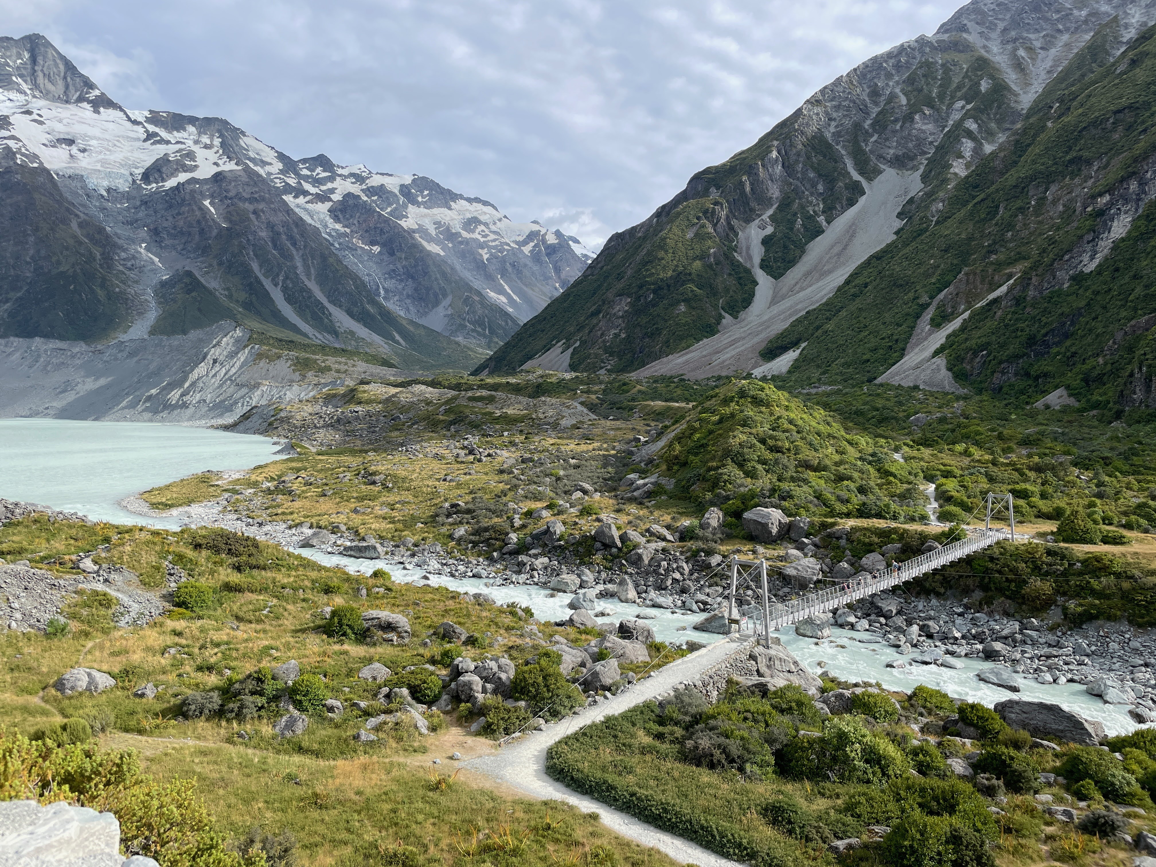
The next morning the sky was a little grey, but we set off on the Hooker Valley Track at about 8.30 am, starting right beside our campsite, and supposedly 3 hour return and about 6 kms. The walk turned out to be excellent, and although it was cloudier than yesterday, it was good walking weather and, more importantly, still no rain ! We had to cross 3
 |
| Swing bridge over Hooker R. |
"swing bridges" across the Hooker River, but after Milford we were old hands at these ! The walk up through the valley was excellent, with the peak of Mt Cook coming and going in the cloud. We crossed the Hooker River on the bridges, seeing Lake Mueller which is fed from the Mueller Glacier, and following the track up the valley,
 |
| Mt Cook |
passing large moraine ridges and humps, which eventually opened up into the wider tussock vegetation Valley before the steeper climb up to Hooker Lake. As we climbed up, the wind was suddenly much stronger and colder, and then as we crested the rise, we found the Lake was full of Ice Bergs that had broken away from the face of the glacier. A wonderful, and totally unexpected, sight ! But it ws quite cold on the edge of the Lake, so after a brief rest, we turned round and headed back down the valley, arriving back at our campsite in time for some lunch. An excellent morning.
 |
| Icebergs in Hooker Lake |
 |
| Mt Cook thru window |
After a gorgeous sunset, (and a light rain shower) we had dinner and a game of cards before turning in. Next morning was again bright and sunny, so after breakfast we packed up and headed down the valley into Mt Cook village, where we parked at the Sir Edmund Hilary Alpine Centre, paid our money and went in. It was moderately interesting, but was as much about the local area as it was about Hilary. But worthwhile, nevertheless. Once again, stunning views out of the windows which have clear views of Mt Cook. Ironically our next destination was the Franz Josef glacier, which as the crow flies was probably only about 5 kms from our campsite at Mt Cook, but unfortunately there is no way across the mountains (except by private helicopter !) so we had to drive some 450 kms back down through Wanaka, then across to the west coast and up. So we drove
 |
| Lake Hawea |
out beside the beautiful Lake Pukaki (doing these drives twice is certainly no hardship !), through Twizel (coffee stop !), and down towards Wanaka. Just before Wanaka we turned N and after a short distance found ourselves beside yet another gorgeous blue lake - This time Lake Hawea. It was only about 4 pm, but it was such a pretty spot that when we saw a campground right beside the road, nestled on the edge of the lake, it only took us about 30 seconds to decide to stop for the night ! Stopping early also gave us the chance to do some laundry, and go for a walk through the campsite around the side of the lake, before making our supper and turning in. Great day.
 |
| Lake Wanaka |
On the road reasonably early, we drove up the western edge of Lake Hawea - Cool breeze, but once again, stunning views - Still with clear blue skies !! After about an hour on the side of Lake Hawea, the road cut inland a little, across a spit of land, and literally 3 minutes later we were on the eastern side of yet another blue lake - this time Lake Wanaka !! About 30 minutes drive up here we came to a little town called Makarora, about which the Lonely Planet Guide book says it is "very much a last frontier - and certainly feels like it. Traffic rolls through, but
 |
| Makarora Country Cafe |
then Makarora settles back to silence". So not a lot there then ? Except they forgot the Makarora Country Cafe. We drove straight past it, but did a U turn and went back .....and found an absolute gem. Once an old garage in
 |
| Mixed Flock toilets ? |
the middle of nowhere, it has now been tastefully developed into a coffee shop with a campsite out behind. And their snacks and pies and cakes were just superb - fresh flower petals everywhere, just excellent presentation. I had a bacon and egg pie and it was scrumptious ! What a great little spot !! And you HAVE to see how they marked the toilet doors 😂
 |
| The Blue Pools |
Just half an hour further up the track we saw a sign to "The Blue Pools", so we
duly stopped and went on the walk that was signed as a 15 minute, 1 km walk. It was a very pretty walk through the trees, but unfortunately when we reach the Blue Pools, the sandflies were already there and wanting a meal ! So most people took a quick look then came back, although a few hardy souls were down on the edge of the river in their bathers, having a swim ! Very pretty pools, and a pleasant little walk, even though my Strave GOS measured it as about 4 kms ! But we were rapidly learning about how bad sandflies could be - Apparently a W coast speciality - But no guide book mentions them !!
 |
| Hells Gate, Haast Pass |
Just a little way up the winding road that is the Haast Pass we came to Hell's Gate - A bridge over a steep ravine where obviously in winter, or spring, when the rivers is in spate, it would be truly wild. Today, a little less so, but still impressive and well worth stopping. Then just a little further down the road it was another walk to Thunder Creek Falls - Once again a pleasant walk through the woods to the falls that are about 90 feet high. We then
 |
| Jackson Bay, end of the road |
followed the Haast River out to the coast and the Tasman Sea, and set off to find a place to stop for lunch. We had decided to turn south at Haast because we had read about a small settlement about 45 kms away which was apparently on of the most remote early settlements, Jackson Bay. About half way there we found a deserted turning onto the beach - And nearly got blown away by the wind ! Obviously a normal situation here as all the trees were leaning over from the
 |
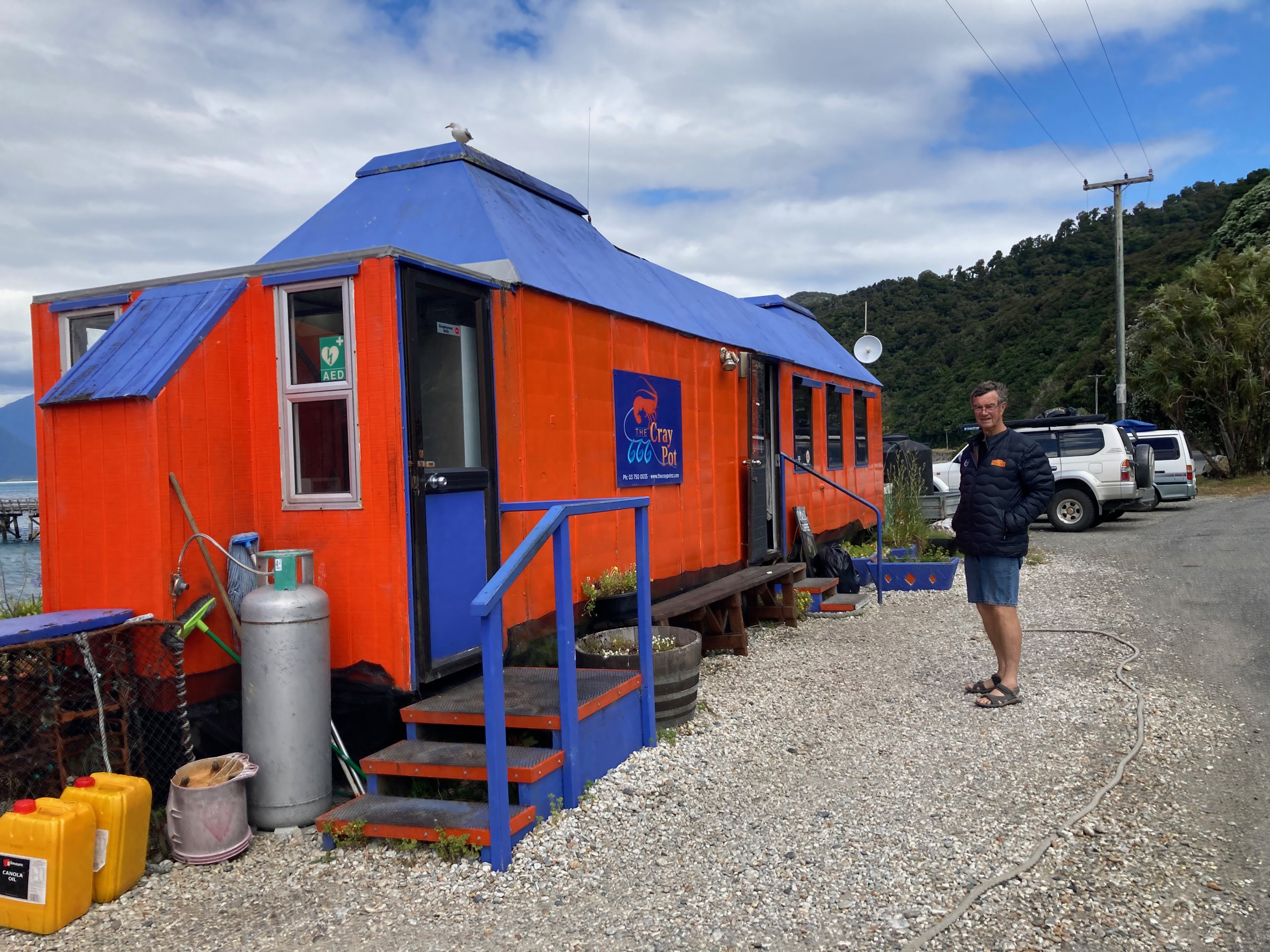
| The Cray Pot |
incessant wind ! After our sandwich we headed on to Jackson Bay, and yes it is remote ! A gravestone commemorating a shipwreck in 1862, and a memorial to the early settlers in 1875. And right in the middle was a bright orange hut called The Cray Pot ! Unfortunately they were just closing up for the day, so all we got was an ice cream - Shame that - Could have done with a bit of Lobster for lunch ! Next time. Leaving Jackson Bay and seeing the rock slides along the road, it is obvious that this only access road does have problems. It looks as though when they do have a rockfall they just bulldoze the debris across the road and into the sea !!
 |
| Dawn on Lake Paringa |
We then went on up the coast road to Knights Point, where the road turns away from the sea and at about 5.30 pm we found a great free DoC campsite on the shore of Lake Paringa. It was a lovely spot - except for the sandflies !! There seem to be two cicada calls - one is much higher pitched, and the usually cicada noise, but the other is much lower - More of a clicking sound, which had us puzzled. We finally spotted a cicada making that clicking noise, and could even see its rear legs moving in time to the clicks. Question answered - Its just a cicada ! On waking up the next morning we were in thick cloud, but as I walked around the clouds melted away as the sun broke through - A magical few minutes on the edge of the lake watching the clouds slowly disappear. Black wine gum.
 |
| Franz Josef glacier |
About an hour up the road we found a Salmon Farm, and thought we might get a coffee. Unfortunately w big coach load of tourist had just got there before us, so after waiting around a while, we decided to leave - But not before we spotted some shower gel in their little shop called "Kiwi Willy Wash" !! Read the label in the photos !! from the Salmon Farm we continued up to Fox Glacier village, where we were able to refill our cooking gas bottle that the Hire Company had obviously not filled, as well as dump our waste and top up the water tank. We had an excellent coffee in the village and then went to try to walk up to the Fox Glacier - But it was a long walk and apparently one it still then a long way from the face of it. Having been right up to and on glaciers in Alaska and Patagonia, I didn't see the need to go an look at the face of a glacier from a distance !! So we then moved on to Franz Josef village - Slightly larger and more active than Fox - And had a wander around. We then went off on the walk to the Glacier - Although it is closer than the Fox Glacier, one it still some distance away from the face, which is disappointing. But it was a pleasant enough walk, despite it actually starting to rain while we were up at the end of the path. Oh no - I had big plans for tomorrow !!
 |
| Glaciers in the sky |
I had planned a helicopter ride for the next morning, up to the glaciers and Mt Cook, and it was kind of crucial that we had clear skies. So after 2 weeks of fine weather, was it going to rain on the one day we wanted sun ?? Nothing we
 |
| On the glacier |
could do, so we headed out to the campsite that I had pre-booked just outside of town. Not a lot of choices here for free camping, and I had been told things get busy out here and it was advisable to book. However, when we got there, on the shores of Lake Mapourika, we found only 2 or 3 others there !! Very pleasant spot - And the rain soon stopped ! Next morning we were in the office of Glacier Country Helicopters by the designated 9 am, and after weighing everyone we
 |
| Mt Cook in background |
set off in the little bus to the helipad. I am not going to go into great depth about how good it was, but as soon as we found out that our pilot was called Poppy (our eldest grand daughter is called Poppie) Janet's day was made ! We had a wonderful flight up into the mountains, over all the glaciers, and we eventually landed on some snow at about 5900 ft, and had some time to throw snowballs and take photos. And the weather ??? As you can see from the photos - CLEAR BLUE SKY !! Black wine gum !!
 |
| Okarito Lagoon |
Once back in town we went for breakfast and coffee at the Landing Bar - Excellent eggs benedict andcoffee. After that, it was time to head north again, although we did take a detour out to Okarito where there is a big lagoon that was once a thriving Gold Mining town. Now it is a sleepy village, with mostly holiday houses, but very pleasant. Got a nice little camp site right there on the beach, too ! But we had to keep heading north - and we stopped for lunch on the shores of Lake Ianthe before arriving in Hokatika by tea time. We went for a wander through town,
 |
| Hokatika beach |
visited the supermarket for supplies, and then went out to the beach - The following weekend there was to be a driftwood sculpture competition there, and there was no shortage of supplies on the beach. Unfortunately with a set time for us to arrive in Picton to catch the ferry to the N Island, we have to keep moving - We don't have the luxury of being able to just wander at leisure. Our campsite for the night was yet another DoC free campsite, inland a bit, NW of Hokatika. Once again a delightful spot, and we settled in for the night.
Decided on a walk in the morning, so set off on what was listed as a "90 minute loop". We took about
 |
| On our steep walk |
40 minutes longer and it turned into a VERY steep and rocky climb, and later aVERY steep and rocky descent. These NZ walks are certainly what I would call a "walk" - More of a hike. But good, nevertheless. Having done our exercise for the day, we headed into Greymouth, about which again the Guide Book doesn't have a lot to say, but we had a
 |
| In Monteith's brewery |
target. Since we arrived in NZ we had ben exploring a few different beers, but had settled on one very pleasant Hazy, made by Monteith Brewery, in Greymouth ! So as it was lunch time, we headed over there and found a great set up, and some excellent food. Janet had the Gurnard Fish & Chips and it was excellent. After a couple of their beers, we were ready to stop, so we found a Top 10 (pay, but very good) campsite down by the beach, and did some laundry and relaxed for the afternoon. Sunset on Greymouth beach was superb.
 |
| Brunner Mine chimney |
Today was the day we were to leave the W coast and head over towards Christchurch on the E coast. The railway journey across from Greymouth to Christchurch is listed as one of the great scenic rides in the world, and I have wanted to do it for some time. Unfortunately, we had a hire van, and so the train journey was out. So I planned to follow the railway line as closely as possible - And the first thing I found was that the railway didn't actually follow the main road to start with, but actually goes slightly N from Greymouth, before dropping down beside Lake Brunner at Moana before it joined up with the main road. I found the smaller road I wanted and we set off - And immediately came to a big old brick chimney. We parked and found out this was the Brunner Coal Mine which had exploded in 1896, killing 65 miners - Still NZ's worst single work accident site. Just as we were about to set off across the bridge to explore the old mine works, the heavens finally opened and it started to pour with rain. Was our weather luck finished ? Needless to say, we jumped back in the car - We weren't about to spend an hour walking around in the open in the pouring rain ! So our journey up the West Coast of New Zealand was now over. We had not seen everything, but what we had seen and explored had been absolutely fantastic.
Except for the Sandflies !! We were not sad to be (hopefully) leaving them behind !!
Rest of the photos of gorgeous mountains and lakes can be found here :-
https://photos.app.goo.gl/QR96sqfSZffcYMh7A


No comments:
Post a Comment